Blog Image

Plods 2012

Plodding 2012

To record walks in 2012 by the WG plodders

Pictures can be viewed and uploaded here http://plodphotos2012.metcas.me.uk

Walks done 2011

Walks done 2010
Walks done 2009
Walks History can be found here

Use the Walkhighlands site to display GPX files.
Note upload .gpx files as .txt

Limpsfield Chart

Surrey Posted on Sat, September 08, 2012 15:40:06

Walk
Date: 22nd August 2012
Where: Limpsfield Chart

Parking: Carpenters Arms and village green

Designer: Ian
Pub: Carpenters Arms

Report

This was a 5.9 mile circular walk through a bit of east Surrey and a bit of west Kent, with a (limited) view of Chartwell at the easternmost point of the route. Eight people and two dogs participated, and the weather was better than expected for the occasion. The first half of the walk crossed the High Chart, which is a heavily wooded area. After Chartwell and Mariners Hill, we descended to low lying fields for the return journey. Near the end of the walk we met up with Phil, who had explored the area by car before reaching Limpsfield Chart. The walk ended with a long climb up a tarmac roadway back to the Carpenters Arms. The Apres-Plod entertainment was provided by the ubiqitous Morris Dancers, and a few glasses of Westerham Ale.

Route

GPX file: (with .txt suffix added)

Map: (1:50000 jpeg image)


West Hoathly

Sussex Posted on Tue, August 21, 2012 19:52:35

Date: 1st August

Where: West Hoathly

Designer: Pete F

Pub: Vinols Cross Inn

Turnout was 8 plus Thaba and two new additions: Dexter and Dizzy. They are a pair of black labradors who’ve just joined the Forman household. The walk was clockwise from Finches Field car park, 6.5 miles with 280 m of ascent.

The bulk of the walk was dry, the rain being contained to West Hoathly. There was a very light drizzle as we set off and slightly more as we arrived back. Those of us who had left coats behind were not bothered by it.

The route started through Sharpthorne, partly over the Bluebell railway tunnel. We were then in open countryside for most of the rest of the walk. We were able to take in Highbrook which had been skipped on the Ardingly walk in May. The Smokery was open, so we had a quick look in there.

On the way down the hill towards Fulling Mill Farm we saw a herd of deer. Dexter decided to have a closer look but came back eventually.

In the pub afterwards the dogs slumped by the table. This was on the route from the main bar area to the toilets but no-one seemed to mind picking their way over the obstacle course.

Route: GPX file (with .txt suffix added)

Map: PDF file (1:50k)


Gatwick-Nutfield

Surrey Posted on Wed, August 15, 2012 13:27:49

Date: 18th July
Time: 17:30
Where: Schlumberger House
Designer: Roy C.

Pub: Station Hotel

GPX:

PDF:


Shoreham

South Downs Posted on Wed, June 27, 2012 09:25:11

Date: 4th July
Time: 18:00
Where: Old Shoreham
Designer: Mark L.

Pub: Red Lion

GPX:

PDF:


Staplefield

Sussex Posted on Tue, June 26, 2012 19:59:49

Date: 20th June

Where: Staplefield

Designer: Pete F

Pub: The Jolly Tanners

Turnout was 12 plus Tarber, including some new faces.

The weather was kind to us, a pleasant evening with only a few stretches that were slightly muddy underfoot. We started on the green opposite the Jolly Tanners and walked 7.0 miles anti-clockwise. Some of the southern paths had featured in plods of previous years but for the most part the route was new. Although not a match for some of the other walks the vistas were generally good and it was quiet.

As we emerged back on the green at the end of the walk Morris dancing was finishing at the Victory. Fortunately they had a second session booked at the Jolly Tanners. Several of our party had not heard of Morris dancing, let alone seen it. While waiting for that to start we sat out in the fine garden drinking a good selection of ales.

Route: GPX file (with .txt suffix added)

Map: PDF file (1:50k)


Leith Hill

Surrey Posted on Fri, June 08, 2012 20:43:34

Date: 6th June

Time:18:00

Where: The Plough, at the junction of Abinger Road and Wolvens Lane, Coldharbour, RH5 6HD

Designer: DT.

Pub: The Plough

Route:

The walk will start by going south east past Anstiebury Mound, then on to find the Roman Road, then will swing West and North to get to the tower on Leith Hill. We will then enjoy the glorious view. At that point the chance of a devious short cut may be too tempting for some, but anyone with a little more determination will want to continue north to get to Tilling Springs, before returning to Coldharbour.
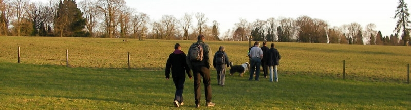
Report:

The walk was accomplished last night by eight of us: Dawsoa, Mr Loveridge, Simon Barnes, Pete Forman, Zimms, Rob Russell, Ian Clement and Yours Truly.

A First, I think, in that seven of us were all there on time and waiting for Rob to arrive, when we heard the flapping of feet and Rob RAN around the corner and into sight. He only lives “A couple of miles away” so he ran to the start. The average level of fitness on this walk was very high, with seven of us contributing very little to it.

We started heading south from Coldharbour and those of us without waders were immediately soaked as the grass was long and the rain had just stopped. We got through the fields and found the Roman Road without problems, then continued south and west. Mr Ian Clement had to have the concept of a view explained to him, which is a concern. We saw some deer in the fields and plenty of pheasant and rabbits.

It had to be said that we were slightly competent. Nobody fell over a stile, or lost anything, or wandered off in the wrong direction, or went too quickly, or too slowly.

Eventually we got through some woods and could see the Leith Hill Tower, which we approached from the south. We took the direct route straight towards it, but Ian needed a rest near the top of the tree line. Fortunately there was a bench and a view.

At the top we took the opportunity of having a good faff. Some people wanted to go straight to the pub, as my efforts to sell them the idea of a couple more miles to see Tilling Springs were in vain. We headed off towards the pub, but at the last moment decided that we should continue on, so we turned north and wandered along the track to Tilling Springs, and even Zimms agreed that it was actually quite nice. Mr Loveridge took photos.

We headed back towards Coldharbour and the cars. Rob started to run home. Dry shoes were a pleasure to put on and the pub’s own beer was particularly good.

DT.


Southease-Lewes

Sussex Posted on Thu, May 17, 2012 09:07:29

Date: 23rd May

Time:18:07

Where: Southease Station

Designer: Mark L.

Pub: John Harvey Tavern

Route:

This is a one-way walk so you either need to catch the train to Southease from Gatwick (or other preferred station) or park in Lewes and catch the train from there.

About time I got round to the report….

Fortunately the train from Lewes to Seaford is designed as a connector…. therefore it waited for the London train and the people travelling down from Gatwick were able to catch it despite their late arrival. (It was also useful for Terry D. as he wasn’t as quick as Clark Kent at changing and only just caught the train…).

A few minutes late a crew of 8 made it’s way down to Southease. It was a very pleasant evening so the turnout was a tad disappointing but that’s their loss smiley.

The first climb of the day was accomplished with ease – though there was a certain amount of trepidation as we walked with Tarber through a herd of cattle; fortunately the bull’s attention was directed elsewhere. From the top of the downs we had fine, if somewhat hazy, views before dropping down into the Glynde valley.

Across the A27 we arrived in Glynde and stopped for a well deserved pint of Harvey’s in the Trevor Arms. No one chickened out and caught the train back to Lewes so we all continued over Caburn Down towards Lewes. As Mr Zimmermann was to remark later this climb seemed to go so much more easily…

We arrived at the John Harvey Tavern in good time for their Jazz night. That and an excellent pint of Harvey’s rounded off a fine evening.

GPX:

PDF:


Ardingly

Sussex Posted on Thu, May 17, 2012 08:39:46

Date: 18th April

Where: Ardingly – public car park opposite the Ardingly Inn

Designer: Andy D.

Pub: The Oak

Just a short post to get the details of this walk on the blog.

A really good turnout considering the lousy weather. After a certain amount of faffing around (which allowed DT to turn up before we left) we departed a bit later than intended. The route took us south across the old railway line then east towards Horsted Keynes. We made very slow progress due to the muddy paths and when we got to the road south of Horsted Keynes station we had to make a decision as to whether to complete the course or bail out with a more direct route back to Ardingly. As we’d been making slow progress due to the treacherous surfaces and were running somewhat later than intended it was decided to take the sensible decision and cut the route short.

We managed to get back to the Oak before dark and dried out in front of the very welcome fire in the bar area!

Route:GPX file (with .txt suffix added)

PDF:


Next »